
How Do Drone Operators Near Me Enhance Real Estate Listings?

Updated: Oct 4
Every agent wants their listings to stand out, and drones have become one of the best tools for the job. If you've never hired a drone operator, though, it's fair to ask what you're actually paying for. Here's what we do, how to tell a good operator from a cheap one, and why it moves the needle.

What Do Drone Operators Do?
A drone operator captures aerial photos and video using a drone with a serious camera on it. The short version: we get angles you can't get from the ground, which means a complete view of the exterior, the lot, and everything around it.
The job is more than sending a drone up, though. A good pilot flies lines that show off the architecture, the landscaping, and the neighborhood without making anyone seasick. That's the difference between footage that sells a place and footage that just exists.
There's a licensing piece as well. Flying a drone for any commercial purpose in the US requires an FAA Part 107 certificate, and a real operator carries liability insurance on top of it. If you're comparing quotes and one is dramatically cheaper than the rest, that gap is usually where it lives.
How to Vet a Drone Operator
Operators are not interchangeable, and the differences show up in the final gallery. A few things worth asking before you book:
Part 107 certification. Required for paid work, and easy for them to show you.
Liability insurance. A million in coverage is the normal ask, and plenty of HOAs and commercial property managers want proof before you fly.
Airspace handling. Ask how they deal with controlled airspace, because around Greenville, Columbia, and Richmond it comes up constantly.
Turnaround. Aerials do you no good if they land after the listing goes live. Ask for the delivery window in writing.
Sample work in your market. A wooded Upstate lot shoots differently than a flat Richmond subdivision, and you want to see they've handled both.
What the Aerials Do Once They're in the Gallery
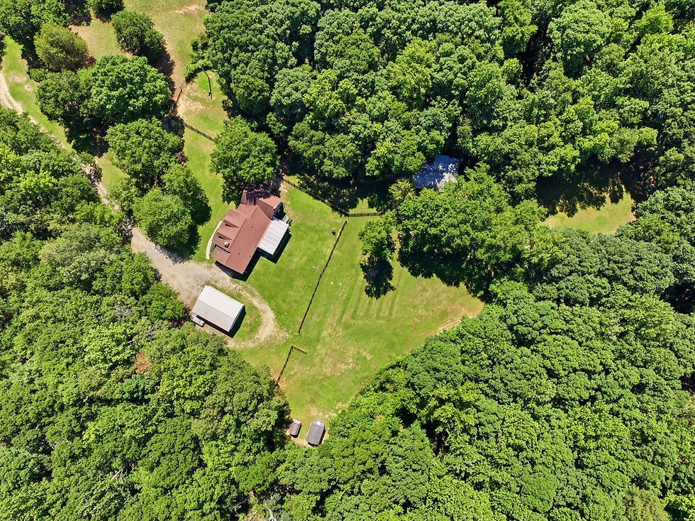
The short version: aerials give buyers scale and setting. A wide frame from above shows how the house sits on the land, what backs up to it, and how far the lot actually goes, and those are the photos buyers bring up at showings. They also sell the location, because parks, water, and the street itself read from the air in a way a front-lawn photo can't manage. Drop one orbit and one pull-back into a walkthrough or a 3D tour and an out-of-town buyer can get serious about a property they've never stood in.
We broke that down properly, ten ways with examples, over in drone photography near me for SC and VA listings. This post is the other half of the question: what you're hiring, and how to tell whether you hired well.
The Cost vs. Benefit of Hiring a Drone Operator
Yes, hiring a drone operator costs money. But stronger presentation tends to mean quicker sales and stronger offers, and listings that look expensive have an easier time justifying their price. In a competitive market, that math usually works out in your favor.
Think of it as marketing spend rather than a photo fee. More eyes on the listing, better first impressions, less time on market. For most properties, the aerial package earns its keep.
The payoff also scales with how much land is involved. A townhouse on a shared lot gets less out of it. Ten acres outside Anderson, a waterfront lot, a home backing up to a golf course or a wooded buffer, those are the ones where skipping aerials means the listing never shows what it's actually selling.
When Aerials Aren't the Right Call
We'll say it plainly: not every property needs drone work. A mid-rise condo with no exterior of its own. A house wedged between two identical houses on a small city lot. A listing where the neighboring property is the thing you'd rather buyers didn't study too closely. In those cases the money does more good on twilight shots or a 3D tour. Ask your photographer what they'd spend the budget on if it were their listing, and take the answer seriously.
What the Pilot Is Actually Deciding Up There
Twenty-five minutes of flight time hides a lot of small calls. The first is altitude. Go too high and the house shrinks into a roof in a field of trees. Stay too low and you lose the lot. Most residential frames land somewhere between 60 and 120 feet, and the right number depends on how much land you're trying to show and how tall the trees around it are.
The second call is where the sun is. A house facing north is a problem in the middle of the day, because the front elevation sits in its own shadow while the roof blows out. We'd rather shoot that one in late afternoon with the light raking across the front than fight it at noon. If your listing faces north or east, say so when you book. The time slot matters more than the gear.
Then there's the craft stuff that shows up the second it goes wrong. Keeping the camera square so the house doesn't lean. Holding the horizon level on the wide frames. Bracketing exposures against a bright sky so the roof keeps detail instead of going to paste. Shooting the same feature twice, once high for context and once lower for the detail, so there's something to choose from in the edit instead of one frame and a prayer.

Permission, HOAs, and the Neighbor Question
The part nobody thinks about until it's a problem is permission. Airspace authorization covers the flight. It doesn't cover the ground you launch from, and it doesn't settle a neighbor who walks over to ask what you're doing.
A few practical notes from shooting these markets every week. Launch from the subject property rather than the street when you can, because it keeps everything on the seller's land and it makes the conversation short if anyone asks. Plenty of HOAs in the Upstate and around Richmond have their own rules about flying over common areas, and it costs nothing to check before shoot day. If the property is tenant-occupied, the tenant should hear it from the agent and not from the sound of a drone over the back yard. Commercial property managers almost always want the insurance certificate in hand beforehand, so send it ahead instead of standing in a lobby waiting on an email.
None of that is complicated. It just goes badly the first time it happens on site with a seller watching.
What Happens When the Flight Can't Happen
Sometimes it can't, and how an operator handles that day tells you more than the portfolio does.
Wind is the usual culprit. Sustained wind past roughly 20 mph and the orbits get shaky, and shaky footage attached to a listing is worse than no footage at all. A low ceiling or steady rain does the same thing. When that happens the flight moves and the ground work goes ahead anyway, so the visit isn't wasted and the aerials join the gallery a day or two later.
The airspace side is covered above, and the honest version is that a denied grid needs lead time nobody has on shoot day. So ask about the reschedule policy before you book rather than after. A reasonable answer sounds like the next available slot at no extra charge when weather cancels a flight. A shrug is also an answer.
The Transformative Role of Drone Operators in Real Estate
Drone work gives buyers a perspective regular photography can't touch, and it makes listings noticeably more enticing. Striking visuals, property features in context, tour-ready footage. We shoot aerials every week for agents around Greenville, Spartanburg, and Anderson, and we wrote up how we approach drone photography for Upstate SC real estate if you want the details.
Where "near me" actually reaches, and why it matters
The phrase people type is local. The answer is logistical. We cover three metros out of two bases: Greenville, Spartanburg and Anderson in Upstate South Carolina, Columbia and the Lake Murray side of the Midlands, and the Richmond metro in Virginia, out through Henrico, Chesterfield, Hanover, Mechanicsville and Glen Allen. An operator who is genuinely near you can hold a morning slot without building a two hour drive into it, and that is what lets you book good light instead of whatever slot is left over.
Ask two logistics questions before you ask the price question. How far will they travel without a trip charge, and how many shoots do they stack in a day. Somebody running five jobs across a metro is going to shoot yours at 1pm, and 1pm is the worst light of the day for a house.
The airspace is different in every one of these markets
This is where an operator earns the word local. All three markets have controlled airspace, and it does not sit in the same place twice. Our Upstate drone guide goes deeper on the South Carolina side, but here is the short version for each.
Upstate SC. Greenville Spartanburg International sits between the two cities, and Donaldson Field is just south of downtown Greenville. A lot of listings on the south and east sides of Greenville fall in a grid that needs authorization before takeoff.
Columbia. Columbia Metropolitan is southwest of downtown, and its airspace reaches over a good stretch of Cayce and West Columbia. Jim Hamilton sits closer in to town.
Richmond. Richmond International is east of the city, and its Class C shelves reach over Henrico and out toward Sandston. The ground closest to the runways is exactly where instant approval runs out.
LAANC turns most of this into a one minute approval from a phone, because the FAA publishes a grid with an altitude ceiling on every square. The squares that read zero are the ones that matter, because there is no instant path at all and the only route left is a coordination request that can take weeks. An operator who works your market knows which addresses sit in those squares before quoting you a shoot date. One who does not will find out on the morning of the shoot, with your seller standing in the driveway.
What being close by does for your turnaround
Proximity pays off twice, once at the shoot and once at delivery. The reshoot is the real test. If a storm rolls through and the aerials come back flat and grey, somebody who lives forty minutes away can swing back Thursday morning. Somebody who drove two hours is going to tell you the photos are fine. Once the frames are in hand, what they do for the listing is a separate question from who flew them.
So get the reshoot policy in writing before the weather turns it into a conversation. Ask about turnaround on aerials specifically too, because drone frames usually take more editing work than ground frames, and they are the ones most likely to hold up a whole gallery.
Ready to give your next listing that edge? Call Beyond All Media at (864) 714-0724 in the Carolinas or (804) 913-3013 in Richmond.


Comments