
7 Innovative Uses for Drone Technology in Commercial Photography

Updated: Oct 4
Drones changed commercial photography in a way few tools ever have. Shots that used to need a helicopter or a boom lift now come off a battery the size of a sandwich. We fly ours almost every week, and the range of jobs it touches still surprises me. Here are seven ways drones earn their keep in commercial work.

1. Aerial Event Coverage
Ground-level event photos miss the thing that makes a big event feel big: scale. From a couple hundred feet up you get the whole crowd, the layout, the tents and stages and parking in one frame. Festivals, grand openings, race days. One aerial tells the story that thirty ground shots can't.
Organizers love those frames because they sell next year's event. The wide aerial becomes the poster, the social banner, the cover of the sponsor pitch. If you promote anything that draws a crowd, one clean drone pass usually pays for itself.
2. Real Estate Photography Revolution
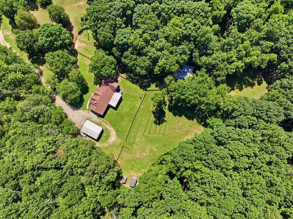
This is where we live. Aerials show a property's layout, lot lines, and surroundings in a way ground photos never will. Buyers see how the house sits on its land, what's behind it, where the neighborhood pool is. On acreage and waterfront, the aerial is the shot buyers scroll to first. We wrote up our whole approach in our Upstate SC drone photography guide.
Aerials also catch what ground shots hide: the roofline, a creek at the back of the lot, how the driveway actually flows. Listings with strong aerial content hold attention longer, and attention is what books showings.
3. Dynamic Marketing Content Creation
For marketing, drone footage is the cheapest production value there is. An opening aerial makes a small business promo feel like a network spot. Tourism, builders, venues, even a company showing off a big installation, they all get the same lift from a few clean passes.
In practice the aerials become the backbone: the opening shot, the transitions, the closer. Mixed with ground footage they give a video rhythm and scale, which is exactly how we build the video work we deliver at Beyond All Media.
4. Enhanced Landscape Photography
Landscape shooters used to be limited by where their boots could take them. Now a ridgeline, a river bend, or a stretch of shoreline that's unreachable on foot is a ninety-second flight away. Compositions exist today that simply weren't possible ten years ago.
That reach matters beyond pretty pictures. Wide aerial frames document erosion, storm damage, and development pressure at a scale ground photos can't communicate. The images do the arguing, which makes them useful to conservation groups as well as galleries.
5. Cinematic Storytelling
Directors used to rent helicopters for shots a drone now gets before lunch. A slow push over a treeline into a reveal. A chase threaded between buildings. Aerial moves add drama and geography to a story and anchor the viewer in the world you're building.
By now the drone is just part of the kit, same as a gimbal or a slider. The craft is restraint: one deliberate aerial move lands harder than ten. Used well, it gives even small productions a sense of scale that used to cost studio money.
6. Inspections and Surveys from Above
Not everything a drone does is pretty. A lot of it is practical: roof inspections, construction progress checks, site surveys. The drone grabs clear, detailed images of places nobody wants to put a ladder, and it does it in minutes with nobody at risk.
What commercial actually means on our schedule in SC and VA
The seven uses above cover a lot of ground, but the jobs that actually land on our calendar in Greenville, Columbia and Richmond fall into a handful of buckets, and each one wants something different from the pilot.
Retail and shopping centers. The broker wants the parking field, the anchor tenants and the road frontage readable in one frame. That is usually 150 to 200 feet, shot square to the building line rather than at an angle.
Industrial and warehouse. The shot that matters is the truck court and dock doors, plus one high wide frame showing rail or interstate access. Owners care about clearances and circulation, not about a pretty sky.
Multifamily. Amenity deck, pool, parking ratio, and the walk to whatever the neighborhood is selling. These fly lower and closer than people expect, because the point is the property and not the skyline.
Hospitality. One approach shot from the road so a guest recognizes the turn in, then the pool or patio at twilight.
Raw land for brokers. Boundaries beat beauty here. We fly a grid and shoot the corners so the listing can actually show where the lines fall.
Where this sits next to our construction coverage
If the building is still going up, that is a different job with a different rhythm. Progress work gets scheduled by milestone or by month, the deliverable is the same comparable frame every visit rather than a hero shot, and the safety planning is heavier because people and equipment are moving underneath you. Our construction drone guide covers that side, and we go deeper on the video version in commercial drone video for construction documentation. This post is about the finished asset: the building that is leasing, selling or opening next month. If you are working a Richmond property specifically, the Richmond commercial photography guide pairs the ground set with the aerials.

What gets delivered, and what it costs you in time
A commercial aerial set usually comes back as 8 to 15 stills, plus a 20 to 40 second clip if video was ordered. On site we need about 45 minutes to an hour for a single building, longer if the property has multiple elevations or we are waiting on light.
The thing that eats a commercial schedule is almost never the flying. It is waiting for the parking lot to clear, for the box truck at the dock to pull out, or for the landscaping crew to finish. If you can get the property manager to give us a quiet window, usually early morning before the center opens, you get a noticeably cleaner set and you get it faster.
When aerials are the wrong spend
Worth saying plainly. If the asset is a suite inside a larger building, or an interior-only retail space, aerials add almost nothing. Good interiors and a floor plan will do far more for that listing. Same story for a single tenant office on a busy corner, where the drone frame mostly shows you traffic. Put the money into the ground set and skip the flight.
Farms run the same play to monitor crop health and irrigation across whole fields in a single flight. Builders use it to document progress week over week. Fast, repeatable, accurate. That's why aerial documentation keeps spreading into new industries.
7. Innovative Wildlife Photography
Wildlife photographers use drones to watch animals without crowding them. With some altitude and a quiet approach you can document behavior that would vanish the moment a person walked up. Researchers lean on the same footage to track populations and migration.
Newer drones are quieter, fly longer, and carry better cameras, so the images keep improving while the disturbance keeps shrinking. It's a rare case where the better technology is also the more respectful option. Good pictures, lighter footprint.
What a Commercial Drone Shoot Actually Looks Like
People are usually surprised how little of a drone shoot is spent flying. Most of it is planning. We pull the site up on a map the day before, check what airspace it sits in, look at where the sun will be, and work out which side of the building looks good at which hour. By the time we show up, the flight is mostly already decided.
On site, the flying itself normally runs twenty to forty minutes, depending on how big the property is and how many angles the client wants. We shoot stills and video on the same trip, because a second visit costs everybody money. Then the files come back for editing, and that is where most of the actual hours go.
The Airspace Rules That Affect Your Shoot in SC and VA
Commercial drone work in the US requires an FAA Part 107 certificate. That one is not optional, and it is a fair thing to ask any operator about before you hire them. After that, the biggest scheduling factor is airspace. Flights are capped at 400 feet above ground level, and anything inside controlled airspace needs authorization before takeoff.
That matters more than people expect in our markets. A good chunk of Greenville sits under the shelf around GSP, Columbia has the same situation with CAE, and a lot of the Richmond metro falls near RIC. Most of those authorizations come through LAANC and clear in minutes, but some zones still need a manual request that can take days. If your property is close to an airport, say so early.
What to Line Up Before You Book
A little prep on your end makes the shoot go faster and the images come out better.
The full address, plus a note if the site is near an airport or a hospital helipad
Whether you need stills, video, or both, and where the footage is going to live (listing site, social, a pitch deck)
Any features you want made obvious, like acreage, water access, parking, or how the lot actually sits
A window of a few hours rather than a hard time, so we can fly when the light is right
Someone reachable on site if gates, dogs, or locked areas are in play
Weather is the one piece nobody controls. Steady rain or wind much above 20 mph grounds the flight, so building a backup day into the schedule saves a lot of scrambling later.
If a project of yours could use a view from above, Beyond All Media flies licensed drones across Upstate SC, Columbia, and Richmond. Call the Carolinas at (864) 714-0724 or Richmond at (804) 913-3013.


Comments