
10 Reasons Why South Carolina Aerial Photography is Transforming Real Estate Marketing

Updated: Aug 18
Aerial photography has gone from a nice extra to something buyers kind of expect, especially in South Carolina where so much of a property's appeal is the land and the setting. Here are ten reasons it's changing how listings get marketed.
1. It shows the whole property
From the air you see the full layout, the yard, the pool, how the place sits on its lot. That's context a ground shot can't give you.
2. It tells a better story
An aerial puts a home in its neighborhood, near the parks and the streets and the water. That's the kind of story buyers connect with.
3. It gets more eyeballs
Aerial shots stand out in a feed. They get the clicks, and clicks get your listing in front of more people.

4. It sells the neighborhood
You can show the parks, schools, and shops nearby, and for a lot of buyers location matters as much as the house itself.
5. It clears up the layout
Property lines, outbuildings, how it all fits together. An aerial answers those questions before they turn into confusion.
6. It reaches out-of-town buyers
Folks relocating to South Carolina can size up a property and its surroundings from a screen, hundreds of miles away.
7. It makes big lots make sense
On acreage, the size is the whole point, and you only really feel that from above.

8. It's good bang for the buck
It's not a huge spend, and a stronger listing tends to move faster and hold its price better.
9. It works on every channel
The same aerial shots play on the MLS, social, a flyer, a website. One flight, a lot of mileage.
10. It sets you apart
Plenty of listings still skip it. Showing up with sharp aerials makes yours look like the one that's handled.
What separates a good listing aerial from a forgettable one
Ten reasons are fine, but they only pay off if the shots are any good, and plenty of aerials out there are not. Here is what moves a drone photo from filler to the frame that sells the listing.
Altitude is the first thing people get wrong. Higher is not better. Climb too far and the house shrinks into a roof sitting in a field of green, which tells a buyer nothing they wanted to know. Most residential aerials that work sit somewhere between 60 and 150 feet. High enough to show the lot, low enough that the house is still the subject.
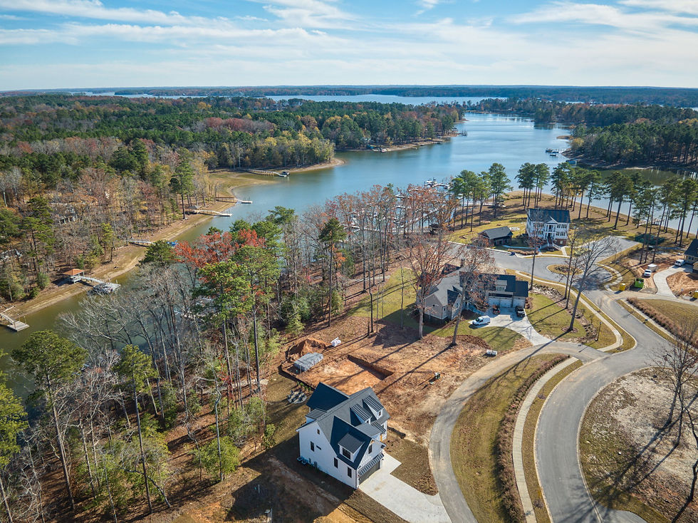
Angle matters just as much. A shot pointed straight down reads like a survey map. Come in at 30 to 45 degrees and you get the roofline, the yard, and the horizon in one frame, and the property starts to look like a place instead of a parcel.
Then there is the sun, and the rule is the same as it is on the ground. Fly with the light behind you so the front of the house is lit, and pay attention to which way that front faces. A north-facing elevation on a South Carolina afternoon sits in its own shadow most of the day, and editing only takes you so far.
Keep the horizon level while you are at it. A tilted horizon in an aerial is the same tell as a leaning door frame in an interior shot. Nobody names it out loud. Everybody feels it.
The shot list we fly on a South Carolina listing
A flight is not one picture. On a typical residential property we come back with something close to this:
A front elevation from around 80 feet, angled down, house centered with the driveway leading the eye in
A rear elevation showing the pool, the deck, or whatever the backyard is actually selling
Two corner obliques so a buyer can read the shape of the house and the roofline
A wider context frame that pulls in the street, the treeline, and anything nearby worth knowing about
On acreage or waterfront, a boundary shot high enough to take in the whole parcel at once
That is five to eight keepers off a flight that takes fifteen or twenty minutes on site. If a property has a real feature, a lake frontage, a barn, a long tree-lined approach, that earns its own frames on top. Which South Carolina properties justify the extra flying and which ones honestly do not is the whole subject of our rundown on where aerial actually pays off.
Where those shots actually go
The common mistake is treating the aerial as one hero image at the top of the MLS listing and then forgetting about it. One flight should feed four or five different places.
On the MLS, lead with the ground exterior and put the aerial second or third. The aerial answers the question a buyer forms right after they decide they like the house, which is what sits around it.
On social, crop vertical. A wide 16 by 9 aerial squeezed into a phone feed turns into a green smear with a roof in the middle. Export a 4 by 5 and a 9 by 16 from the same file and one flight quietly becomes a second set of assets.
In a listing presentation, the aerial is the slide that wins the appointment. A seller already knows what their house looks like from the sidewalk. Showing them what it looks like from 100 feet is what makes the marketing plan feel like something real instead of a promise.
And in print, the context frame does work a floor plan cannot. A flyer with a well-composed overhead tells a buyer more about the lot in one glance than three paragraphs of description ever will. If you are looking for someone local to fly it, our notes on hiring a drone photographer nearby cover what to ask before you book.
Let's put your listing in the air
If you've got a South Carolina property that deserves the full treatment, Beyond All Media shoots aerial photos and video along with interiors and 3D tours. Ring the Carolinas line at (864) 714-0724 and we'll get you scheduled.
More from us: read our full SC & VA real estate photography guide, or book a shoot.


Comments